Understanding Crop Health from Space with Remote Sensing in Agriculture
Farming has always been about observation. You look at the colour of the leaves, feel the soil with your hands, watch how fast a crop is growing, and make decisions based on experience. That instinct still matters but today, it has limits.
Because by the time a crop looks unhealthy, the damage has often already begun.
This is where remote sensing in agriculture quietly changes the game. It gives farmers and agribusinesses the ability to understand crop health before problems become visible, using data captured from space. Not to replace experience, but to sharpen it.
Let’s unpack how this works, why it matters, and how it can actually help you make better farming decisions.
Why understanding crop health early is so important
Every crop goes through stress. That’s normal. What decides yield and quality is how early you detect that stress and how precisely you respond.
The challenge is that many stress factors such as water imbalance, nutrient deficiency, disease onset, don’t show obvious symptoms at first. Plants adjust internally long before leaves turn yellow or growth slows. Traditional field scouting has three limitations:
- It is time-intensive, especially on large farms
- It captures only small sections at a time
- It often detects problems after impact has already started
Remote sensing helps overcome all three by offering regular, field-wide visibility, even when you’re not physically present.
What is remote sensing in agriculture
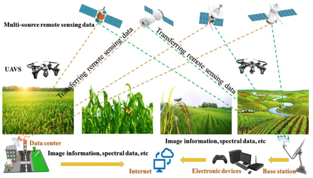
Remote sensing in agriculture means observing crops from a distance, typically using satellites, to understand how they are performing.
Satellites orbit the Earth and capture images of agricultural land at regular intervals. But these aren’t just photos. They measure how crops reflect different wavelengths of light, some visible to the human eye, others invisible.
Why does that matter?
Because plants interact with sunlight in predictable ways. Healthy plants absorb light differently than stressed plants. By analysing those patterns, we can infer crop condition across entire fields.
Think of remote sensing as a crop health report that updates automatically, showing how your field is changing over time, not just how it looks on one particular day.
How satellites see crop health
Plants use sunlight to photosynthesise. In doing so:
- They absorb most red light
- They reflect a large amount of near-infrared light
Healthy vegetation reflects more near-infrared light because of its internal leaf structure. When plants are stressed due to lack of water, nutrients, or disease that reflectance pattern changes.
Satellites are designed to measure these differences precisely. Over time, these measurements reveal:
- growth trends,
- weak zones,
- sudden stress events,
- and recovery patterns after intervention.
This is where raw satellite data becomes actionable agricultural insight.
How does NDVI in agriculture turn satellite data into real decisions?
Among the many metrics used in remote sensing, NDVI (Normalized Difference Vegetation Index) is the most widely adopted in agriculture because it simplifies complex satellite data into something farmers can act on. NDVI looks at how plants reflect red light and near-infrared light and combines that information into a single index value. You don’t need to focus on the mathematics behind it, the real value lies in what the index reveals.
In practical terms, higher NDVI values generally indicate healthier, denser vegetation with strong growth, while lower values point to sparse crop cover, uneven development, or some form of stress. What makes NDVI especially useful is its role as a guide rather than a diagnosis. It does not explain why a problem exists. Instead, it clearly shows where attention is required within a field. That distinction is critical, because it helps farmers prioritise field visits, reduce guesswork, and make more focused, data-driven decisions that save both time and resources.
How NDVI helps you understand crop health from space
Let’s translate NDVI into real-world farming scenarios.
Identifying uneven crop growth
Many fields are not uniform. Soil type, drainage, past cropping patterns, and irrigation distribution all vary within the same plot.
NDVI maps highlight these differences clearly. Instead of treating the entire field as equal, you can see which zones are consistently weaker and which are performing well.
This allows targeted action rather than blanket treatment.
Detecting early stress before visible damage
Stress often begins subtly. A crop under mild water stress or nutrient imbalance may still look green and upright, but internally its performance has already dipped.
NDVI detects these changes earlier than the human eye, giving you valuable lead time, often the difference between correction and loss.
Tracking crop development through the season
Because satellites revisit the same fields regularly, NDVI allows you to monitor progression, not just condition.
You can see:
- whether growth is accelerating or slowing,
- whether recovery after rainfall or fertilisation is happening,
- whether certain sections lag behind consistently.
This time-series view is one of the biggest advantages of remote sensing in agriculture.
Remote sensing applications beyond NDVI maps
While NDVI is the most common index, remote sensing supports a wider range of agricultural decisions.
It can assist with:
- Crop area estimation and seasonal planning
- Yield forecasting, when combined with historical data
- Irrigation scheduling, by identifying zones under moisture stress
- Input optimisation, reducing overuse of fertilisers and chemicals
- Risk assessment, especially in large-scale operations
For agribusinesses, exporters, and input suppliers, this data also improves planning, sourcing decisions, and supply chain reliability.
What are the limits of remote sensing in agriculture and why do they matter?
Remote sensing is a powerful tool, but building trust means being honest about what it can and cannot do. Understanding these limits ensures the data is used wisely and effectively.
It cannot replace field knowledge
Satellite data highlights patterns, not root causes. A low NDVI area may result from pests, poor soil quality, waterlogging, nutrient deficiency, or even planting gaps. Physical field checks, often called ground truthing, remain essential to identify the real issue and decide the right corrective action.
Weather can interfere
Cloud cover can block satellite visibility during certain periods, reducing the availability of usable imagery. While most systems compensate by analysing data across longer time windows, short-term gaps can still occur.
Interpretation always matters
NDVI values vary by crop type and growth stage. Comparing fields without context can lead to incorrect conclusions. Good interpretation considers crop stage, weather patterns, and local conditions.
Used with awareness, remote sensing becomes a reliable decision-support tool, not a replacement for experience.
How can you start using remote sensing in agriculture?
You don’t need to transform your entire operation at once to benefit from remote sensing. Starting small helps build confidence and consistency.
- Begin with one crop and one field to keep monitoring manageable
- Review NDVI data regularly to understand normal patterns and seasonal changes
- Flag unusual drops or weak zones that stand out from the rest of the field
- Visit only the flagged areas on the ground instead of scouting the entire plot
- Identify the underlying cause, such as water stress, nutrient issues, or pests
- Take corrective action and continue tracking NDVI to observe recovery
Following this step-by-step approach turns remote sensing into a practical habit rather than a one-time experiment, helping you make better decisions with less effort over time.
Why remote sensing in agriculture is becoming essential
As farming faces tighter margins, climate variability, and rising input costs, decisions based purely on intuition become riskier. Remote sensing brings:
- better visibility,
- earlier intervention,
- reduced guesswork,
- and more efficient use of resources.
It allows farmers and agribusinesses to move from reactive problem-solving to proactive crop management.
Overall…
Remote sensing in agriculture doesn’t distance you from your farm, it brings you closer to what’s really happening in it.
When you combine satellite insights with on-ground experience, you gain clarity. You stop chasing symptoms and start managing systems. You intervene earlier, apply inputs more precisely, and build resilience into every season.
Understanding crop health from space isn’t about technology for its own sake. It’s about making smarter decisions, protecting yield, and farming with confidence – long before problems become visible.
At Invade Agro Global, this data-driven, systems-led approach aligns with our broader vision of building smarter, more resilient agricultural ecosystems. You can explore more insights, solutions, and perspectives on modern agriculture on our website, where technology and on-ground expertise come together to support better farming decisions.
Once you experience this shift, there’s truly no going back.